GR131 Canary Islands, Day 17: Thursday, Jan 29, 2026
I woke up at 5:00 AM to catch up on the writing I was too exhausted to finish last night. We had promised the security guard who visited us yesterday that we would be out of the area before sunrise, around 8:00 AM.
By 7:00 AM—nearly an hour before dawn—we were already on the move. Hiking through Gran Canaria (GC) involved many steep inclines and descents, which really took a toll on Inger’s back and hips. Knowing that Tenerife and the smaller islands ahead would also be demanding, we made a decision before starting yesterday’s trek.
Inger has two former colleagues who spend their winters on Tenerife. Before we left home, she had planned to visit them once we reached the island. Our new plan is for Inger to hike only one day on Tenerife. This would lead us to a road where she can catch a bus to visit her friends, allowing her to make the visit while giving her back a much-needed break. I’ll continue the trek across Tenerife alone, and we’ll reunite before crossing over to La Gomera. We’ve estimated four days of hiking for the Tenerife stretch.
Currently, we were hiking toward the first bus stop, El Vero, on route TF-21. It was a 1.5 km (0.9 mile) walk down along the TF-21 toward La Orotava. We hiked with our headlamps on through a thick fog. We arrived early, and the darkness faded as we waited. Inger has to take three different buses to reach Tejina de Isora. The first leg of her journey started at 8:05 AM.

We said our goodbyes, and I hiked a short distance further down to find a path back onto the GR131. Right then, I realized I really had to go to the bathroom. Like, really had to go. Oops! I forgot to get the toilet paper from Inger. She’s usually in charge of the TP, and I’m in charge of the trowel.
Fortune favors the bold, though. Just 50 meters (164 feet) ahead, I surprisingly stumbled upon a cafe that had just opened. I rushed in, found the restroom in the basement, and took care of business. While there, I noticed three rolls of toilet paper with varying amounts left. I seized the opportunity and «borrowed» the smallest one. After all, I had several days of hiking ahead of me.
Feeling a bit sheepish, I went upstairs and ordered a caffè latte. I couldn’t exactly just use the facilities and leave. Besides, I had plenty of time. Today’s stage was only supposed to be 15 km (9.3 miles). That would put me right at the border of Teide National Park, where they are very strict and will fine you if you’re caught camping inside the park. The plan was to camp just outside the boundary and cross the park tomorrow.
At the cafe, I finished my writing, published it to Facebook and our blog, and charged my electronics. By 9:00 AM, I left to reconnect with the GR131.
Even though today’s stage was short, it involved significant elevation gain. The first few kilometers were rolling hills, but the final 8 km (5 miles) consisted of a continuous climb of 1,050 meters (3,445 feet). I must admit my legs felt a bit tired last night after yesterday’s 1,300-meter (4,265-foot) climb, and I was curious how they’d hold up today. I got my answer quickly: they felt fresh and ready.


It was still foggy when I started the ascent, which wound through the forest. After a few hundred meters of climbing, I broke through the sea of clouds into blue skies above the treeline. It got warm fast, and I had to adjust my layers. I had just finished doing so when a girl came down the trail, clearly on a long-distance trek of her own.
It was Klára from the Czech Republic. She was also hiking the GR131 on Tenerife. Interestingly, the Czech Republic is the country from former Eastern Europe where we’ve met the most hikers in recent years. They are always friendly, interesting, and speak great English. When Inger and I hiked the PCT three years ago, we met another lovely Klára from the Czech Republic. Aside from hiking, she’s a talented baker and has—much to my delight—inspired Inger to bake some incredible cakes.
I had a long, pleasant chat with today’s Klára and mentioned my YouTube channel. It turned out she had already watched several of my videos while researching the Fishermen’s Trail.

I continued upward at a brisk pace. I tend to hike faster when I’m alone—honestly, a bit too fast. A little later, I met young Bente and her boyfriend (whose name escapes me), both from the Netherlands. They were also doing the GR131. They mentioned Norway was their favorite vacation spot; they’d visited several times, including a trip to my hometown Narvik.

Right on the border of Teide National Park—actually, slightly inside—there is a restaurant. The final hundred meters of climbing to get there were brutal. I hadn’t eaten since breakfast and was starving and thirsty. I refueled with chicken, fries, cake, and plenty of fluids at the restaurant.


I sat there for over an hour, eating and weighing my options. It was still early in the day. I checked the maps and trail profiles. It’s a good thing Inger wasn’t there to see me staring intensely at my phone, plotting my next move. Finally, I made a decision: I would cross the national park today. That would mean an additional 18 km (11.2 miles) and 500 meters (1,640 feet) of climbing. It would be a long, grueling day, especially since I already had over 1,100 meters (3,600 feet) of climbing in my legs.
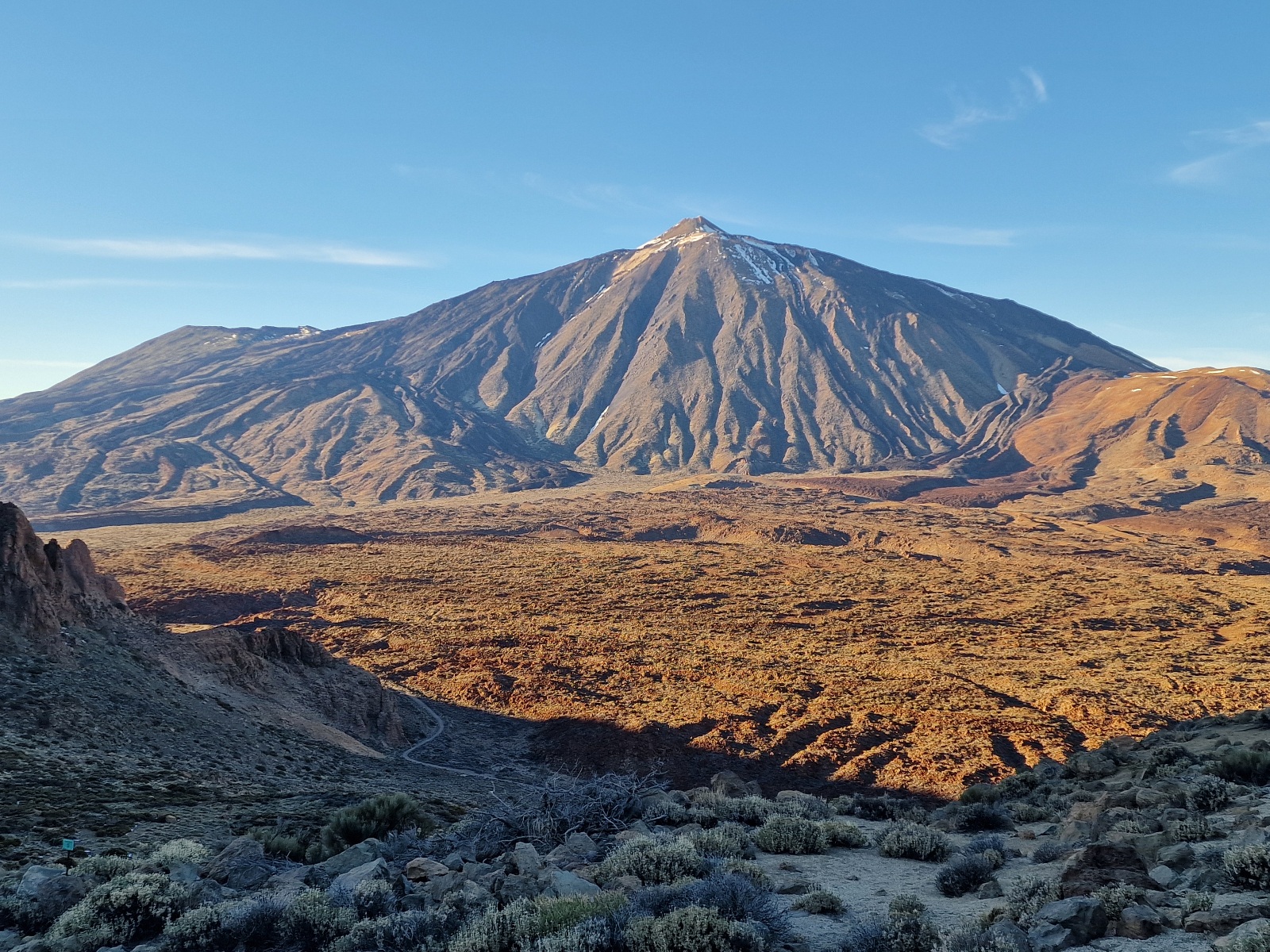
It was 2:30 PM when I left the restaurant. The national park sits above the treeline and consists of a nearly flat desert where I could maintain good speed. There were patches of leftover snow in the shadows. I had passed 2,000 meters (6,561 feet) in elevation. Mount Teide eventually appeared to my right; it wasn’t a goal for this trip, as you have to apply for a permit well in advance to summit it.
7128706594952364499.jpg)
5923292304809002490.jpg)
7503681222602269183.jpg)
3700750151180042625.jpg)
7107012856664567421.jpg)
Then came the climb to the pass at the trail’s highest point: 2,414 meters (7,920 feet). On the way up, there were sections of snow and ice on the path.
1064442649810099037.jpg)

3266597320027160560.jpg)
4830207903075099474.jpg)

From the other side of the pass, I looked down at the sea of clouds on the eastern side of Tenerife. It sat higher than the clouds on the west. To the east, I could see the peak of Gran Canaria poking through the mist.


Then began the descent over very rocky and difficult terrain. I had to drop 300 meters (984 feet), wondering if I’d end up back in the fog tonight. After 32 km (19.8 miles), I finally exited the park. According to the map, there should be a spot to camp just 2 km (1.2 miles) past the boundary. The last kilometer was on smooth, pleasant, coal-black lava sand.


The map was right. Twenty minutes before sunset, I found a perfect spot and pitched my tent. The sea of clouds and the treeline sat just below me. The temperature was 10°C (50°F).
I’m camping at 2,100 meters (6,890 feet) with no cell service.

Today’s total: 34 km (21.1 miles) and 1,640 meters (5,380 feet) of elevation gain.