The Colorado Trail, Day 27. Monday, August 25, 2025.
It was only 4 °C (39 °F) right after sunrise yesterday, so I expected a cold night. It was clear during the first part of the night, but it got cloudy later. It therefore wasn’t so cold in the morning, at 5 °C (41 °F). The outside of the tent was still wet from last night’s rain, and there was a lot of condensation inside.
All the hikers at the campsite had said they would start hiking at sunrise at 6:30 a.m. Inger and I started then, and we saw that Chuck and Rouky were also ready soon, but I didn’t see the girls. Chuck said they had started an hour ago without saying goodbye.
I was wearing a shirt, long-sleeve shirt, and fleece, and Inger was wearing her down jacket. We both had gloves on. Even though the trail climbed from the start, we didn’t get properly warm until after several kilometers.
The layer of clouds above us didn’t stretch all the way to the eastern horizon. When the sun came up over the horizon, we got sunshine for about a quarter of an hour before it rose into the cloud cover.

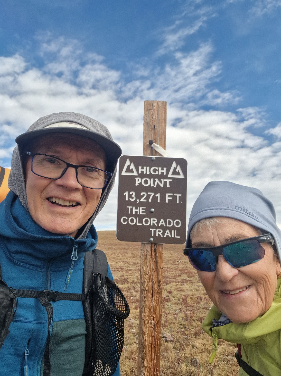
We crossed the treeline after 10 minutes and were now on the climb to the highest point on the CT. Even though it was cloudy, we had a great view as we hiked precisely on the Continental Divide.


Chuck caught up with us just before we reached the highest point, after 10 km (6.2 miles). The highest point, 4,041 meters (13,258 feet) above sea level, is located just below the summit of Coney Point, 4,064 meters (13,333 feet). I wanted to hike up to this peak while Inger continued on the trail. I decided to walk up slowly, but it’s not so easy without a path. The thin air caused me to almost hyperventilate, and I had to sit down to catch my breath. There was a cairn at the relatively flat summit. I took some pictures before walking back down to the trail and meeting Inger.


The trail now went down into a valley, passed Carson Saddle, and continued downhill.


It had been completely cloudy until now, but I saw an opening in the clouds, and the sun came out.
We had hiked 12 km (7.5 miles), and we took the opportunity for a food break while we dried the tent in the sun. The sun was only out for half an hour, just enough time to dry our wet tent.
The trail then went down into another valley that we followed westward. The trail followed the right side of the valley, climbing 300 meters (984 feet) up to an unnamed pass, 3,940 meters (12,926 feet) above sea level.


Just before we reached the top, I heard the first rumble of thunder. It was just past noon. Both rain and thunderstorms were forecast for today. Once at the top, we saw that there were dark clouds in front of us, to our left, and we saw lightning there. If we were lucky, we would stay clear of it, but it’s often difficult to see which direction a storm will take.


We walked quickly down the other side of the pass. As we descended into the landscape, we saw that the storm was staying almost still, and we would pass to the right of it.


After a good 22 km (13.7 miles), we were near a water source where we had considered stopping for the night. We saw that three of the girls had set up their tents nearby. It was time for food and a break, so we sat down. While we were eating, we considered what to do. It was just past 1:00 p.m.; it was early in the day. Our bodies were tired but could handle more. There could be more bad weather. It was going to rain more tomorrow, and it would be good to have done a few extra kilometers today. We’ll continue.
67901911773073364.jpg)
As we were getting ready to go, Chuck passed us. We passed him when he was having lunch a little ways away.
As we started to walk, it began to rain. It was precipitation from the storm nearby. It came down hard enough that we put on our rain gear. Of course, it stopped then.
We kept it on anyway and hiked towards the water source. It would be a «dry camp» tonight, and I filled up 4 liters (1.05 gallons) before we continued.
The trail went over a pass, and to the front right, the valley was really dark. As we walked down from the pass towards the saddle to the next valley, we saw that the storm was getting closer as it thundered. We walked quickly down towards the saddle and up into the next valley, hoping to pass to the left of the storm. A little way up the valley, we caught up with Chuck, and he told us that there would be some campsites a few hundred meters farther up.
We found the spot, and we decided to camp there with Chuck. It had started to rain now. That was enough for today. We had done a lot of elevation gain. Climbing at this altitude is much more strenuous than at sea level.
The rain lasted for several hours while we were in the tent. We heard thunder until sunset. The storms now are not the classic kind that last for a couple of hours in the middle of the day. This one is lasting until evening.
Tonight, we also heard coyotes in the valley.
Considering the conditions, we are very happy with the day. We avoided the thunderstorm, perhaps due to luck. Even though it was mostly cloudy, we had a great view. The entire hike today was above the treeline.
Today’s hike was 27.5 km (17.1 miles) with an elevation gain of 1,226 meters (4,022 feet).
We are tenting at 3,843 meters (12,608 feet) above sea level. This is the highest we’ve tented on this trip, and perhaps the highest on any of our trips.