GR131 Canary Islands, Day 32: Thursday, Feb 12, 2026
The final day on the GR131.
Our campsite sat just above 1,200 m (3,937 ft), and we expected a chilly—though not freezing—night. Despite the clear skies, the temperature never dropped below 13°C (55°F). It was actually one of the warmest nights in the tent on this entire trip. I even took the opportunity to enjoy the incredible starry sky during the night.
Yesterday evening, we saw a sea of clouds a few hundred meters below us on the north and west sides of El Hierro. The cloud cover had been there all day, and I expected it to stick around today as well. We prepared ourselves for a hike in the fog, but when I poked my head out of the tent this morning, the mist had vanished from the area. What a perfect morning!

The distance to the finish line of the GR131 was now only 13 km (8 miles). Once we reached the end, we’d have to backtrack about 4 km (2.5 miles) along the route, then follow a paved road for roughly 12 km (7.5 miles) to reach the nearest bus stop on the north side of the island.
We were hiking shortly after sunrise. The trail started with a descent right away—after all, we had to drop 1,200 meters (3,937 ft) in elevation.
After just 10 minutes of walking, we reached a water station at Cruz de Los Humilladeros. The water we filtered yesterday had a bit of an unpleasant aftertaste, but this water was excellent.

The route followed the ridge for a while before turning 90 degrees to the left, heading straight down toward some small volcanic peaks. There, we hit a paved road which we followed for just under a kilometer to an intersection.


We were now a bit over 4 km (2.5 miles) from the finish line, and since we had to return to this same spot, we decided to hide our backpacks under some bushes to avoid carrying them up and down the final stretch. The intersection was at 460 m (1,509 ft).
The road wound down 300 meters (984 ft) in long curves, but the GR131 went straight down, crossing the road a couple of times. The landscape had changed; the volcanic activity in this area looks significantly younger than what we’ve seen elsewhere on the island.

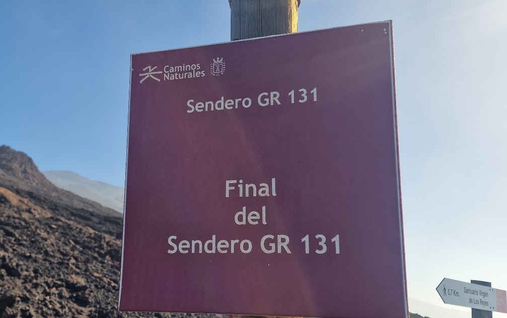
The trail and the road met again at the 150-meter (492 ft) contour line, and the GR131 followed the road for the final 2.5 km (1.5 miles) to the pier, which marks the southern terminus of the route. In addition to the pier, there was a recreation area and restrooms.


Then, it was time to turn around and head back up to the intersection. The temperature was in the low 20s°C (70s°F), and it felt great to be without the heavy packs on the climb.
Back at the intersection, we had a food break before starting the walk along the road toward the north side of El Hierro.
There was very little traffic. After walking 3 km (1.9 miles), only two cars had passed, but then a car stopped when we stuck out our thumbs. A French couple drove us about 6 km (3.7 miles). This left us with only 3 km (1.9 miles) to walk to Pozo de la Salud, where a bus was scheduled for 2:00 PM.

We arrived half an hour before departure, and Inger managed to grab a cup of coffee before we headed to the stop. The bus—a minibus—was delayed. When it finally arrived, we quickly realized why: it had technical issues and kept stalling. The driver had to reset the system every time by flipping the main power switch! I feared we’d need a replacement bus, but we finally made it to Frontera, where we had booked an apartment for the night.

The weather was gorgeous all day until we reached the north side of the island. Then the clouds rolled in, and in Frontera, it was completely overcast.
Today’s stats: 23 km (14.3 miles) and 510 meters (1,673 ft) of elevation gain.