Colorado Trail Day 31. Friday, August 29, 2025.
There was occasional cell phone reception on the ridge where we camped at 3,300 meters (10,827 feet). I checked two different weather apps; both predicted rain for tomorrow, and one predicted a thunderstorm around noon. I also checked Yr. It predicted rain at 7 AM, but for some strange reason, it never reports thunderstorms outside of Norway.
At midnight, we woke up to the sound of drops on the tent fly. I keep the outer door on my side of the tent open at night. This allows for better ventilation and reduces the chance of condensation. I looked through the mosquito netting in an easterly direction and saw dark clouds drifting in from the west. The horizon was still clear. Luckily, it was just a few drops. This happened several times during the night, but the tent was dry in the morning.
The cloud cover meant the temperature was a comfortable 9.5°C (49°F), and there was no condensation in the tent when we got up.
Just before 7 AM, our bags were packed, and we were ready to take down the tent. That’s when a rain shower came, lasting for two minutes—just long enough to get the tent wet. It was really annoying.
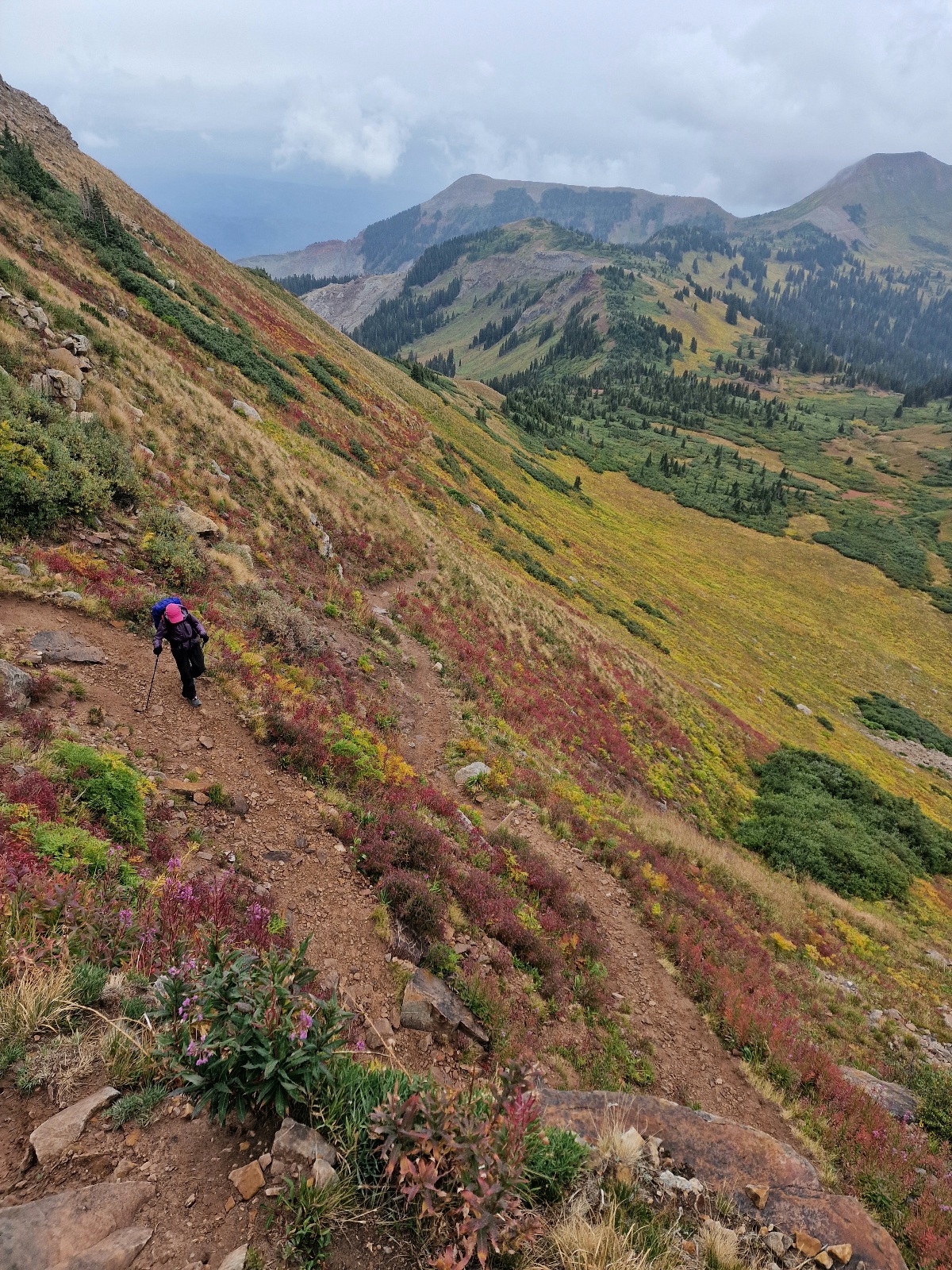
We continued our hike south along the ridge. The trail was still below the tree line, but there were often long, open sections that provided excellent views.


Yesterday’s last water source was 13 km (8 miles) before we camped. The first one today would be after 11 km (7 miles). When we got there, only a trickle of water was running, and it was of poor quality with an oily film on the surface. I filled half a liter that I didn’t filter yet, just to have as a reserve. We still had a bit left from yesterday. The next water source would be another 12 km (7.5 miles) away. It wasn’t hot today, even though the morning was warm, so we didn’t need as much water.
After 14 km (8.5 miles), we took a break for lunch.
While we were sitting there, a young hiker, Bridon from Pennsylvania, came up and asked if we were from Norway. He had heard for a long time that there was a Norwegian couple ahead of him on the trail and had hoped to meet them. It turned out he had a Norwegian girlfriend in Stavanger and had been there this spring. He had even been to Narvik in May of this year. He’ll be returning to Norway long before we do. We had a long and pleasant chat before he hiked on.


The trail continued to climb, and we reached the tree line around noon. Dark, ominous clouds came from the west, and we feared a thunderstorm, but luckily, we were spared. We couldn’t escape the rain, though, so we put on our rain gear. Inger wore her jacket, pants, and a rain cover on her pack. I wore my jacket and a rain kilt. The jacket I’m using on this trip is the super-light Helium from Outdoor Research. The marketing says it’s a rain jacket, but it can’t withstand water for long before it soaks through. In addition, I put on the unique rain cover for my backpack. It also covers my head and shoulders. Regular rain covers often let water get between your pack and your back, and your shoulders often get wet if your jacket isn’t completely waterproof. I avoid all of that with this rain cover. Highly recommended.


The ridge ahead, Indian Trail Ridge, was very exposed, and we were glad there was only rain and not a thunderstorm. Parts of the ridge were a rocky arête only three meters (10 feet) wide. The entire section was truly beautiful, even with a little precipitation.


The high point was at 3,736 meters (12,257 feet). From there, we descended the steep mountainside toward Taylor Lake. The trail traversed downward. Initially, it was a rough scree and rocky terrain. Then it became loose soil with vegetation. Fall had arrived up here, and the colors on the mountainside were indescribable, like a painter’s palette.


After descending barely 200 meters (656 feet), we reached the idyllic Taylor Lake, and I filled up 4.5 liters of water from the small creek flowing from the lake.
We then hiked another two kilometers (1.2 miles) to the Kennebec Trailhead, where we took a food break and had a discussion.


We had now hiked 25 km (15.5 miles) with 1,000 meters (3,281 feet) of elevation gain. The section between Silverton and Durango is 120 km (75 miles), and we had planned to spend five days on it. We had a long stage yesterday and had planned to hike 25 km today and tomorrow. This would leave us with only 10 km on the last day, allowing us to get to Durango early. We have accommodation booked there for two nights.
We couldn’t find a suitable tent site at the Trailhead. Maybe we should just keep going so we could get to Durango tomorrow? There would be few tent sites on the stretch ahead of us, but there might be an option after five kilometers. We decided to continue.
The trail now, after a small climb to Kennebec Pass, dropped steeply into the valley and eventually traversed through a long scree field high up on the steep mountainside. Above the scree field were vertical rock walls with alternating gray and rust-red bedrock.


A little further down, the forest swallowed us. Just before we reached the предполагаемой campsite, a really heavy rain shower hit, and we took shelter under some fir trees, even though we had our rain gear on.
The campsite wasn’t as good as we had hoped. The ground was sloped, and a small root was sticking up where the tent was supposed to be placed. We made sure to position it right in the middle between our sleeping pads.
After we had eaten dinner and settled in, the older bearded guy, Matt, whom we had passed yesterday, arrived. He camped in an even worse spot right next to us. A little later, Karen and Fred arrived. We noticed they took a while to find a spot to set up their tent.
Even though there was a good amount of precipitation today, we had a fantastic hike through very varied terrain and nature.
Today’s hike was 30.5 km (19 miles) and 1,050 meters (3,445 feet) of elevation gain. We are camping at 3,100 meters (10,171 feet) above sea level.