Colorado Trail Day 32. Saturday, August 30, 2025.
The final day.
We didn’t sleep very well where we camped in the forest at 3,100 meters (10,171 feet). The ground was too sloped, and we kept sliding down inside the tent.
I finished writing in the morning and woke Inger up at 6 AM. It was still dark, but twilight would arrive within fifteen minutes. I saw that Matt, in the neighboring tent, was awake with his headlamp on, and a little further down between the trees, I had long seen a light from Karen and Fred’s tent.
At ten to seven, we were ready to go. Matt was also ready to start, but Karen and Fred’s tent was still up, which was odd. They usually start hiking while it’s still dark. Karen came over to us just before we started and said Fred had slept very poorly and wanted to sleep a little longer.
All five of us who camped there had planned to take five days for this section and had booked accommodation in Durango for tomorrow. None of us had found a place to stay in town for tonight. We told Karen that we would probably camp at the campground near the end of the CT trailhead. That was their new plan, too. The trailhead is 5-6 km (3-4 miles) from Durango.
It was six degrees Celsius (43°F) when we started hiking down the trail through the forest. The forest had swallowed us yesterday afternoon and wouldn’t spit us out until we reached Durango.
The valley we were hiking down went in a southerly direction, and we were on the eastern mountainside. This meant we were in the shade, even though it was clear and sunny.


The forest gradually became denser, now a mix of deciduous and coniferous trees. The view was very limited, but after six kilometers (3.7 miles), we noticed we had reached the valley floor, where a creek, Junction Creek, was flowing. It was a narrow V-shaped valley with very steep and tall wooded slopes. The sun hadn’t reached the valley floor yet, and I commented to Inger that it couldn’t get much sun down in this deep, narrow valley. But the vegetation was surprisingly lush. I had never seen such tall trees in a mixed forest before. They were enormous. It seemed they were competing to grow higher than their neighbors to get as much of the limited sunlight as possible. The aspens only had branches and leaves at the very top. There was no point for the tree to use energy on leaves further down, and it had therefore shed the branches there as well. The trees must have been very old, as I saw one that had fallen over the trail and had been sawn through. The growth rings in the thick trunk were as dense as the pages of a bible.
The conifers mostly had branches all the way to the top, but they weren’t very green in the lower part.
The undergrowth was also tall and reached upwards. Fall hadn’t arrived down here, and a plant with beautiful yellow flowers was as tall—often taller—than Inger.


After just under eight kilometers (5 miles), the trail crossed Junction Creek, which was now just a small stream, and went up the western mountainside. We had been hiking for two hours, the temperature was still only six degrees (43°F), and our hands were still cold.
The trail now climbed this mountainside, and when we reached the sunny part, it got warm. The trail climbed a total of over 300 meters (984 feet) steadily up the steep mountainside while we moved down the valley.
Then the trail flattened out and eventually descended into what later turned out to be a side valley. It became warm as we lost elevation.

We went well below 3,000 meters (9,843 feet), which we hadn’t been at in several weeks. After 26 km (16 miles), after the trail took many turns down a mountainside, we came to a river that we crossed on a bridge. We didn’t know it then, but it was Junction Creek, which had now grown larger. Our thirsty throats could now quench their thirst with cold water while we sat in the shade of a large pine tree.
While we were sitting there, Matt arrived. «I’m totally exhausted,» he said before going down to the tempting, clear water in the river. When he came up from the river, he told us there was a motorcycle rally in Durango tonight and all accommodations were full. He had had cell phone reception before the descent and had still managed to get a simple hotel room in Durango for tonight for $400. «I’m done with tent life for now,» he declared.
Matt had started the CT a few years ago but had to interrupt his hike after a fall and injury. This year he continued from Monarch Pass and headed south.
His long white beard makes it difficult to guess Matt’s age. For some strange reason, I didn’t dare to ask directly about his age, but I brought up the topic by mentioning that Inger was born in 1949. «Oh, you beat me by many years, I’m 68.» «You really kick butts,» he said to Inger, impressed.
Matt is staying at the same hostel as us tomorrow. We said our goodbyes and continued the last few kilometers of the Colorado Trail.


There are three categories of hikers on the trail: day hikers or weekend hikers; then there are Section Hikers, like Mad, who hike a trail in sections or just do parts of a trail; the third group is Thru Hikers, like us, who hike a trail from end to end in one go.
Americans, unlike Europeans and especially Norwegians, are very thoughtful and generous in their praise when someone has done something big or reached a milestone in life. They congratulate you.
On the last few kilometers of the CT, we met several local day hikers. When they saw us, a little dirty, and me not having shaved for several days, they asked if we were Thru Hikers. When we confirmed it, they lit up and congratulated us heartily. They were like an audience cheering and congratulating an athlete who had crossed the finish line.
One group of four adults—not young, but not old either, probably siblings or at least family—congratulated us and asked how many days we had taken, etc.
To impress them a little more, I said, «You’re looking at probably the oldest female Thru Hiker on the CT. Inger was born in 1949.»
They looked at each other, thinking. Then one of them exclaimed, «But that’s the year my mom was born! Fantastic! How do you manage to stay so young? You don’t even look tired!»
Inger both likes and dislikes this kind of attention.
We then came to the road a bit before the trailhead and followed the road up to the campground. It’s not a classic campground but a designated area with numbered spots in a large wooded area where you can barely see your neighbor. You drive in with a car and can either pitch a tent or have a camper van or RV. The price is $35 per night. There’s no electricity, running water, or sanitary facilities. Just a toilet—not a flush toilet, but still of good quality.
A sign at the entrance said the campground was full. We went anyway to find the host, whose name was Bob. I explained who we were and our situation. I know that campgrounds often have a Group Site where groups can camp, and hikers are often allowed to camp there, so I asked if we could set up our tent there. The host apologized and said it was also occupied due to the motorcycle rally.

Bob had hiked the CT himself and had a soft spot for Thru Hikers. He thought for a moment. «I have two spots down there,» he said, pointing, «that are for day visitors. You can pitch your tent in one of those. It’s on me, and the overnight stay is on the house.»
What a solution-oriented and generous host. Once again, we were impressed by the friendliness and hospitality we as hikers have been met with in the USA. Is it any wonder we keep coming back year after year?

It was still early afternoon, and we made dinner at the benches and table at the site we were assigned. It was warm and comfortable, but a while before sunset, mosquitoes came out, and we crawled into the tent.

We had been looking out for Karen and Fred, and as the sun went down, a car drove up and stopped at our spot. A seemingly sore and tired Fred got out, followed by a spry Karen. They had gotten a ride from the trailhead up to the campground. They were now camping in the same spot we were assigned.
Today’s hike was 30 km (18.6 miles) and 545 meters (1,788 feet) of elevation gain. We are camping at 2,215 meters (7,267 feet) above sea level.
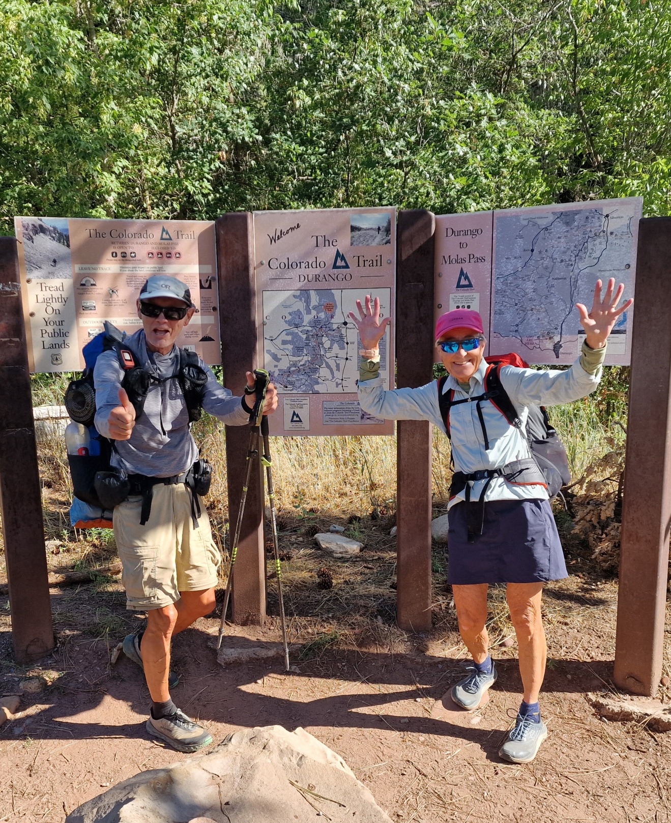
With this, our 777 km (483 miles) hike on the CT, the Colorado Trail, is over.
However, our adventure in the USA isn’t over yet. We have a month until we go home. Now we’re going to relax a bit, then we’ll go to Denver, rent a car, and go on a road trip.

Congratulations!,! I met you on your first day on the trail at the picnic tables at the top of Waterton Canyon. I have been following your journey thru your blog and have found it entertaining. Wish you all the best and hope you are able to return to the USA again for another adventure.
Mary
Waterton canyon volunteer
Hi Mary! Thanks so much 🙂 We absolutely remember meeting you at the picnic table on our first day of the hike. It was a lovely encounter. We’re happy you followed our blog and found it entertaining!
This is our third thru-hike in the US, and we will definitely be back for new adventures sometime soon.