GR131 Canary Islands, Day 13: Sunday, Jan 25, 2026
Last night was crystal clear, and the forecast predicted 4 {C} (39F). That turned out to be spot on; I measured 3.5C (38F) at 6:00 AM. Fortunately, the fog stayed away.
We were camped in a fairly exposed spot, and the massive temperature drop during the night led to heavy condensation—both inside and outside the tent.
We turned in early yesterday and had breakfast at dawn. By 8:00 AM, just after sunrise, we were on the move.
The trail climbed right from the start, so our hands were the only things that stayed cold. Our gloves had gotten damp while we were packing down the wet tent.
The sun’s rays hit the surrounding peaks immediately, but it would take a long time before they reached us down on the mountainside.


After just under 2 km (1.2 miles) and an ascent of 200 meters (656 feet), we reached a junction at a gravel road. We were supposed to continue nearly a kilometer up this road, but it was blocked off with fences and netting. Signs informed us that it was closed due to a landslide.
What now? I checked the map and saw that it would be a massive detour if we had to turn back to find a new route. We decided to squeeze past the barriers and entered a section about 150 meters (490 feet) long where rocks and small boulders had tumbled onto the road. The area above the road was steep with very loose rock.

After nearly 1 km (0.6 miles), we reached another junction and a new barrier, which we squeezed past again. This was the closure for those coming from the opposite direction.
The junction sat right on a pass, offering stunning views on both sides. We met three young Canadian men camping there; they were on a mountain biking trip through the Canary Islands.


Coffee and Logistics in Tirajana
From the pass, the trail wound steeply down 50 meters (164 feet) before leveling out into a gentle descent toward the village of Tirajana.


Even though it was only 10:00 AM, we had to seize the opportunity to visit one of the village’s two cafés. This would be our only chance today.
We sat on a bench in the sun while our wet tent hung over a railing to dry. We weren’t the only guests; the place was swarming with cyclists and motorcyclists.

We also met two young German hikers heading north. Like us, they were taking the opportunity to dry out their tents and gear.
Tirajana, also known as San Bartolomé de Tirajana or Tunte, sits at 900 meters (2,953 feet) above sea level. From here, the route climbs up to 1,730 meters (5,676 feet). Before leaving the village to tackle this stretch, we bought more water to ensure we had enough until tomorrow morning.

Climbing Through the Pines
The first part of the climb took us up to the pass at Cruz Grande, where we crossed the GC-60 road. On the way up, and even further up the mountain, we could hear the motorcycles playing on the winding roads below.
The temperature was only 13C, but the sun and the incline made it feel much warmer. It was actually perfect hiking weather since there wasn’t even a breath of wind.


From the pass, the incline became noticeably steeper, at times winding along stone-reinforced paths. We took a food break during the climb and dried our sleeping bags. They tend to soak up moisture when there’s a lot of condensation—partly from the air and partly where our breath hits the cool surface of the bag during the night.


By the 1,550-meter (5,085-foot) contour line, the steepest section was behind us, and the final stretch up to 1,700 meters (5,577 feet) went through easy terrain in a pine forest. The pines here have 15–20 cm (6–8 inch) needles and look a lot like the Ponderosa pines we’ve seen in the US. However, these are the unique Canary Island pines, which have three needles per bundle. They are more fire-resistant than the Ponderosa; we saw many trees that had clearly been through fires but were still thriving.


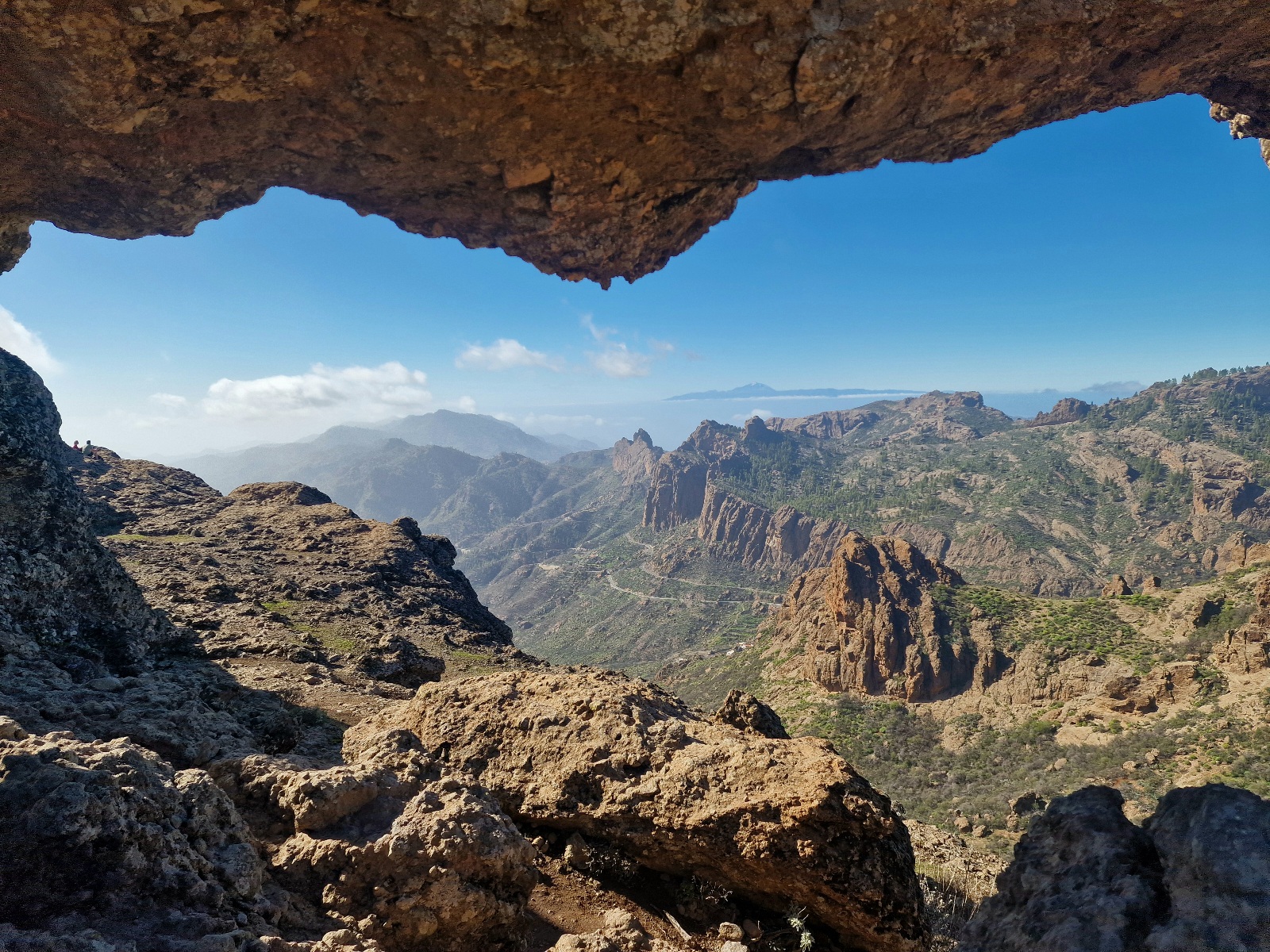
Near the highest point of the trail, there is a sign pointing toward an Arch—a natural stone formation. The detour was only a few hundred meters and well worth the look.


After this, the trail leveled out and undulated through terrain running parallel to the GC-600 and GC-150. There is a designated campsite in this area, but you have to reserve it online in advance as a registered user with an ID card. I had tried this previously but without luck.

We passed the site and continued for a few more kilometers until we found a favorable spot in the pine forest. We sat on fallen logs and ate while waiting for the sun to get closer to the horizon. There were people in the area, so we wanted to wait until just before sunset to pitch the tent.
We found a great spot under a large pine. Having a canopy of trees over the tent helps avoid or minimize condensation during the night.
We are camping at 1,700 meters (5,577 feet). The forecast calls for clear skies and 1 C, (39F)
Today’s stats:
• Distance: 19 km (11.8 miles)
• Elevation gain: 1,170 meters (3,838 feet)